 National Rehab Helpline
Key Numbers
- Listed treatment facilities
- 137closed listings excluded
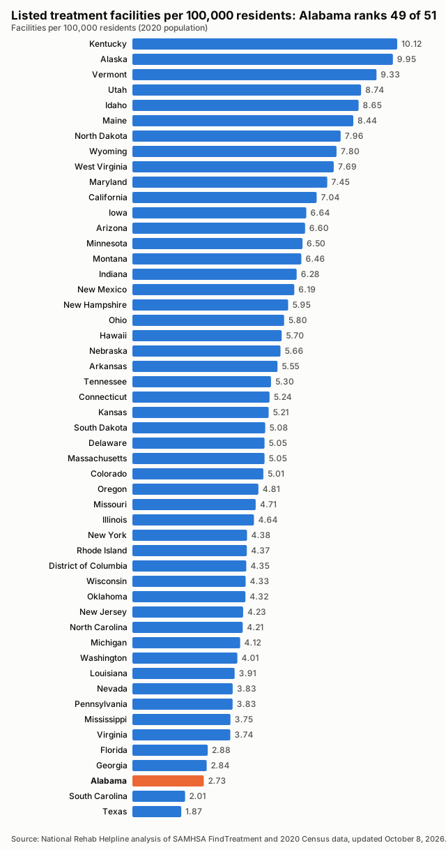
- Facilities per 100,000 residents
- 2.732020 Census population
- Treatment deserts
- 18of 67 counties have no listed facility
- Residents of treatment deserts
- 512,870people in zero-facility counties
- Accept Medicaid
- 77.4%106 of 137 listed facilities
- Population
- 5,024,2792020 Census
Last updated , when the source report was generated.
These figures count listed facilities, not capacity or quality: a listing does not show how many people a facility can treat, how soon, or how well.
How the State Compares
Treatment Deserts
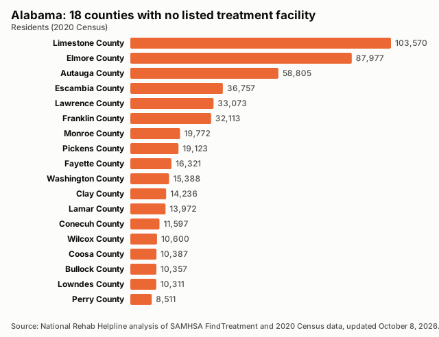
18 counties have no listed treatment facility. Distances are straight-line miles to the nearest listed facility.
| County | Population | Nearest listed facility (miles) |
|---|---|---|
| Limestone County | 103,570 | 12.7 |
| Elmore County | 87,977 | 15.1 |
| Autauga County | 58,805 | 19.1 |
| Escambia County | 36,757 | 12.2 |
| Lawrence County | 33,073 | 19.7 |
| Franklin County | 32,113 | 23.2 |
| Monroe County | 19,772 | 30.3 |
| Pickens County | 19,123 | 23.3 |
| Fayette County | 16,321 | 15.0 |
| Washington County | 15,388 | 20.6 |
| Clay County | 14,236 | 19.6 |
| Lamar County | 13,972 | 18.3 |
| Conecuh County | 11,597 | 32.6 |
| Wilcox County | 10,600 | 35.7 |
| Coosa County | 10,387 | 15.4 |
| Bullock County | 10,357 | 23.6 |
| Lowndes County | 10,311 | 22.3 |
| Perry County | 8,511 | 17.5 |
Desert Counties by Population
Find Care Near Treatment Deserts
All Counties, Ranked
| Rank | County | Population | Listed facilities | Per 100,000 | Status |
|---|---|---|---|---|---|
| 1 | Crenshaw County | 13,194 | 2 | 15.16 | |
| 2 | Greene County | 7,730 | 1 | 12.94 | |
| 3 | Marengo County | 19,323 | 2 | 10.35 | |
| 4 | Sumter County | 12,345 | 1 | 8.10 | |
| 5 | Cherokee County | 24,971 | 2 | 8.01 | |
| 6 | Choctaw County | 12,665 | 1 | 7.90 | |
| 7 | Hale County | 14,785 | 1 | 6.76 | |
| 8 | Cleburne County | 15,056 | 1 | 6.64 | |
| 9 | Walker County | 65,342 | 4 | 6.12 | |
| 10 | Henry County | 17,146 | 1 | 5.83 | |
| 11 | Etowah County | 103,436 | 6 | 5.80 | |
| 12 | Houston County | 107,202 | 6 | 5.60 | |
| 13 | Covington County | 37,570 | 2 | 5.32 | |
| 14 | Butler County | 19,051 | 1 | 5.25 | |
| 15 | Calhoun County | 116,441 | 6 | 5.15 | |
| 16 | Macon County | 19,532 | 1 | 5.12 | |
| 17 | Russell County | 59,183 | 3 | 5.07 | |
| 18 | Tallapoosa County | 41,311 | 2 | 4.84 | |
| 19 | Randolph County | 21,967 | 1 | 4.55 | |
| 20 | Bibb County | 22,293 | 1 | 4.49 | |
| 21 | Chilton County | 45,014 | 2 | 4.44 | |
| 22 | Clarke County | 23,087 | 1 | 4.33 | |
| 23 | Winston County | 23,540 | 1 | 4.25 | |
| 24 | DeKalb County | 71,608 | 3 | 4.19 | |
| 25 | Marshall County | 97,612 | 4 | 4.10 | |
| 26 | Barbour County | 25,223 | 1 | 3.96 | |
| 27 | Jackson County | 52,579 | 2 | 3.80 | |
| 28 | Geneva County | 26,659 | 1 | 3.75 | |
| 29 | Coffee County | 53,465 | 2 | 3.74 | |
| 30 | Talladega County | 82,149 | 3 | 3.65 | |
| 31 | Colbert County | 57,227 | 2 | 3.49 | |
| 32 | Montgomery County | 228,954 | 8 | 3.49 | |
| 33 | Cullman County | 87,866 | 3 | 3.41 | |
| 34 | Marion County | 29,341 | 1 | 3.41 | |
| 35 | Pike County | 33,009 | 1 | 3.03 | |
| 36 | Chambers County | 34,772 | 1 | 2.88 | |
| 37 | Tuscaloosa County | 227,036 | 6 | 2.64 | |
| 38 | Dallas County | 38,462 | 1 | 2.60 | |
| 39 | Jefferson County | 674,721 | 17 | 2.52 | |
| 40 | Mobile County | 414,809 | 9 | 2.17 | |
| 41 | Lauderdale County | 93,564 | 2 | 2.14 | |
| 42 | Madison County | 388,153 | 8 | 2.06 | |
| 43 | Dale County | 49,326 | 1 | 2.03 | |
| 44 | Shelby County | 223,024 | 4 | 1.79 | |
| 45 | Blount County | 59,134 | 1 | 1.69 | |
| 46 | Morgan County | 123,421 | 2 | 1.62 | |
| 47 | Lee County | 174,241 | 2 | 1.15 | |
| 48 | St. Clair County | 91,103 | 1 | 1.10 | |
| 49 | Baldwin County | 231,767 | 2 | 0.86 | |
| 50 | Autauga County | 58,805 | 0 | 0.00 | Treatment desert |
| 51 | Bullock County | 10,357 | 0 | 0.00 | Treatment desert |
| 52 | Clay County | 14,236 | 0 | 0.00 | Treatment desert |
| 53 | Conecuh County | 11,597 | 0 | 0.00 | Treatment desert |
| 54 | Coosa County | 10,387 | 0 | 0.00 | Treatment desert |
| 55 | Elmore County | 87,977 | 0 | 0.00 | Treatment desert |
| 56 | Escambia County | 36,757 | 0 | 0.00 | Treatment desert |
| 57 | Fayette County | 16,321 | 0 | 0.00 | Treatment desert |
| 58 | Franklin County | 32,113 | 0 | 0.00 | Treatment desert |
| 59 | Lamar County | 13,972 | 0 | 0.00 | Treatment desert |
| 60 | Lawrence County | 33,073 | 0 | 0.00 | Treatment desert |
| 61 | Limestone County | 103,570 | 0 | 0.00 | Treatment desert |
| 62 | Lowndes County | 10,311 | 0 | 0.00 | Treatment desert |
| 63 | Monroe County | 19,772 | 0 | 0.00 | Treatment desert |
| 64 | Perry County | 8,511 | 0 | 0.00 | Treatment desert |
| 65 | Pickens County | 19,123 | 0 | 0.00 | Treatment desert |
| 66 | Washington County | 15,388 | 0 | 0.00 | Treatment desert |
| 67 | Wilcox County | 10,600 | 0 | 0.00 | Treatment desert |
Methodology
Every number on this page is calculated directly from public records; no figure is estimated or written by hand.
Facilities are the treatment locations listed in SAMHSA's FindTreatment.gov locator, each counted once by its listing ID. Closed listings are excluded; active and unconfirmed listings are included (unique IDs; closed excluded; active and unconfirmed included).
Density divides the number of listed facilities by the 2020 Census resident population and multiplies by 100,000.
A treatment desert is a county with zero listed facilities. Facilities are placed in counties by their coordinates against Census county boundaries; deserts are only reported when every listed facility in the state has a verified county.
The Medicaid share is the number of listed facilities that report accepting Medicaid divided by all listed facilities; facilities that do not report it count as not confirmed.
Distances are straight-line (great-circle) miles from a county's Census reference point to the nearest geocoded listed facility in any state. They are not driving distances.
These are listed facilities, not capacity or quality: counts describe listings, not beds, wait times, outcomes or proof of access to care.
Known Gaps in This Data
- None reported for this state.
Sources and Reuse
- SAMHSA FindTreatment.gov treatment locator (Substance Abuse and Mental Health Services Administration): Listed treatment facilities, operating status and Medicaid acceptance.
- 2020 Census redistricting data (P.L. 94-171), table P1 (U.S. Census Bureau): State and county resident population (2020).
- 2020 cartographic boundary files, counties (1:500,000) (U.S. Census Bureau): County boundaries for assigning facilities to counties and for the county map.
- 2020 Census Gazetteer files, counties (U.S. Census Bureau): County reference points for nearest-facility distances.
Download this data: County table (CSV) · Full data (JSON)
Licence: this data and its charts are published under the Creative Commons Attribution 4.0 (CC BY 4.0) licence. You may copy, share and adapt them, including commercially. Attribution: credit National Rehab Helpline and link to the source page, https://nationalrehabhelpline.com/data/alabama/.